Unveil the mysteries of past with these remarkable early maps facsimile of the Holy Land and Jerusalem.
These maps are a must have for any collection, and are sure to make a tremendous and overwhelming gift.
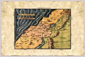
Shows the Holy Land, both sides of the Jordan River, divided among the twelve Tribes of Israel.
The shore line runs from Sidon to Gaza.
The Dead Sea is crescent shaped.
"Itinerarium Sacrae Scripturae" by Heinrich Bunting, 1545-1606. Imprint by Jacobus Lucius, Helmstadt 1585.
From the Eran Laor Cartographic Collection. The Jewish National & University Library, Jerusalem
Not original coloring
This item is printed facsimile of an early map, it is printed on a special "parchment paper" which allows very high quality prints.
This handmade paper is manufactured using age old techniques. Each map is printed individually.
Print Technique: Giclee
Printed on: Bark Paper
Print size: 30x40 cm
Woodcut
Product Availability: 7 days