Unveil the mysteries of past with these remarkable early maps facsimile of the Holy Land and Jerusalem.
These maps are a must have for any collection, and are sure to make a tremendous and overwhelming gift.
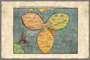
This is a very interesting representation of Jerusalem and the rest of the world as known at the time.
The map shows three continents: Europe, Asia and Africa in the form of a clover leaf with the city of Jerusalem in the centre.
From "Itinerarium Sacrae Scipturae" by Heinrich Bunting , 1545-1606. Imprint by Jacobus Lucuis, Helmstadt 1585 .
From the Eran Laor Cartographic Collection. The Jewish National & University Library, Jerusalem
Not original coloring
This item is printed facsimile of an early map, it is printed on a special "parchment paper" which allows very high quality prints.
This handmade paper is manufactured using age old techniques. Each map is printed individually.
Print Technique: Giclee
Printed on: Bark Paper
Print size: 30x40 cm
Woodcut
Product Availability: 7 days